What is Physical Geography?
http://www.youtube.com/watch?v=IJuxVdZf7IE
"Physical Geography is the study of the Earth’s surface features and processes. It aims to explain the geographic pattern of landforms, soils, water, vegetation, and climate by understanding the processes operating at the surface of the earth, and how these processes interact, affect and complement human activities. Physical Geography at Brock emphasizes the field-based nature of the discipline. Students are exposed to a wide range of geographic studies including geomorphology, glacial studies, climatology, meteorology, biogeography, and environmental studies."
From:http://www.brocku.ca/social-sciences/undergraduate-programs/geography/geography-at-brock#human
From:http://www.brocku.ca/social-sciences/undergraduate-programs/geography/geography-at-brock#human

Introduction to Physical Geography
"The main objective of this online textbook is to introduce students to the exciting field of knowledge known as physical geography. Physical geography is a discipline that is part of a much larger area of understanding called geography. Most individuals define geography as a field of study that deals with maps. This definition is only partially correct. A better definition of geography may be the study of natural and human constructed phenomena relative to a spatial dimension.
The discipline of geography has a history that stretches over many centuries. Over this time period, the study of geography has evolved and developed into an important form of human scholarship. Examining the historical evolution of geography as a discipline provides some important insights concerning its character and methodology. These insights are also helpful in gaining a better understanding of the nature of physical geography.
History of Geography and Physical Geography
Some of the first truly geographical studies occurred more than four thousand years ago. The main purpose of these early investigations was to map features and places observed as explorers traveled to new lands. At this time, Chinese, Egyptian, and Phoenician civilizations were beginning to explore the places and spaces within and outside their homelands. The earliest evidence of such explorations comes from the archaeological discovery of a Babylonian clay tablet map that dates back to 2300 BC.
The early Greeks were the first civilization to practice a form of geography that was more than mere map making or cartography. Greek philosophers and scientist were also interested in learning about spatial nature of human and physical features found on the Earth. One of the first Greek geographers was Herodotus (circa 484 - 425 BC). Herodotus wrote a number of volumes that described the human and physical geography of the various regions of the Persian Empire.
The ancient Greeks were also interested in the form, size, and geometry of the Earth. Aristotle (circa 384 - 322 BC) hypothesized and scientifically demonstrated that the Earth had a spherical shape. Evidence for this idea came from observations of lunar eclipses. Lunar eclipses occur when the Earth casts its circular shadow on to the moon's surface. The first individual to accurately calculate the circumference of the Earth was the Greek geographer Eratosthenes (circa 276 - 194 BC). Eratosthenes calculated the equatorial circumference to be 40,233 kilometers using simple geometric relationships. This primitive calculation was unusually accurate. Measurements of the Earth using modern satellite technology have computed the circumference to be 40,072 kilometers.
Most of the Greek accomplishments in geography were passed on to the Romans. Roman military commanders and administrators used this information to guide the expansion of their Empire. The Romans also made several important additions to geographical knowledge. Strabo (circa 64 BC - 20 AD) wrote a 17 volume series called "Geographia". Strabo claimed to have traveled widely and recorded what he had seen and experienced from a geographical perspective. In his series of books, Strabo describes the cultural geographies of the various societies of people found from Britain to as far east as India, and south to Ethiopia and as far north as Iceland. Strabo also suggested a definition of geography that is quite complementary to the way many human geographers define their discipline today. This definition suggests that the aim of geography was to "describe the known parts of the inhabited world ... to write the assessment of the countries of the world [and] to treat the differences between countries".
During the second century AD, Ptolemy (circa 100 - 178 AD) made a number of important contributions to geography. Ptolemy's publication Geographike hyphegesis or "Guide to Geography" compiled and summarize much of the Greek and Roman geographic information accumulated at that time. Some of his other important contributions include the creation of three different methods for projecting the Earth's surface on a map, the calculation of coordinate locations for some eight thousand places on the Earth, and development of the concepts of geographical latitude and longitude."
If you want to keep reading this article go to: http://www.physicalgeography.net/fundamentals/1a.html
Physical processes
Physical geography is about understanding how sequences of events and activities in the physical world lead to changes in places, landscapes and societies.
Glaciation:
Ice shapes the land through the processes of glaciation and the landforms which are created as a result. Climate change drives melting and this will have a severe impact on many places and people.
Where do we find ice?Ice covers about 10 per cent of the Earth’s surface. This ice is in the form ofglaciers, ice caps and ice sheets. Most ice is found in Antarctica.
About 20,000 years ago, ice covered much of the continent of Europe, including most of the United Kingdom. Ice joined the UK to the rest of Northern Europe and it has covered different areas in the past due to glacial periods andinterglacials. Ice spreads out during glacial periods and gets smaller during warm interglacials. Glaciers also grow and shrink with seasonal changes in temperature.
A glacier is a large mass of ice often shaped like a river that flows very slowly, under the force of gravity.
An ice sheet is a thick layer of ice that covers more than 50,000 sq km. It completely covers the landscape including mountains and valleys.
Today, ice is found in highland areas such as the Alps, and in the far north and south, eg the Arctic and Antarctic.
How do glaciers form?Glaciers develop over many years in places where snow has fallen but not melted. Snow is compacted and turns to ice. The weight of the ice means that it starts to slip down mountain sides over time.
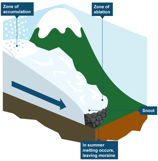
A glacier is a system. There is a zone of accumulation where snow is added. This is normally at the start of a glacier in a highland area. As more and more snow falls, it is compacted so the bottom layers become ice.
Ice moves downhill due to the force of gravity.
Near the end, or snout, of the glacier ice may melt. This is the zone of ablationand is more likely to occur in warm summer months.
Freeze-thaw weatheringIce is very good at shaping the landscape. In cold climates freeze-thaw weathering is active.
If you want to know more about glaciation, Plate tectonics, Rivers and flooding, Coasts, Weather and climate, visit this page: http://www.bbc.co.uk/bitesize/ks3/geography/physical_processes/ ,it also has test and reviews!
Physical geography is about understanding how sequences of events and activities in the physical world lead to changes in places, landscapes and societies.
Glaciation:
Ice shapes the land through the processes of glaciation and the landforms which are created as a result. Climate change drives melting and this will have a severe impact on many places and people.
Where do we find ice?Ice covers about 10 per cent of the Earth’s surface. This ice is in the form ofglaciers, ice caps and ice sheets. Most ice is found in Antarctica.
About 20,000 years ago, ice covered much of the continent of Europe, including most of the United Kingdom. Ice joined the UK to the rest of Northern Europe and it has covered different areas in the past due to glacial periods andinterglacials. Ice spreads out during glacial periods and gets smaller during warm interglacials. Glaciers also grow and shrink with seasonal changes in temperature.
A glacier is a large mass of ice often shaped like a river that flows very slowly, under the force of gravity.
An ice sheet is a thick layer of ice that covers more than 50,000 sq km. It completely covers the landscape including mountains and valleys.
Today, ice is found in highland areas such as the Alps, and in the far north and south, eg the Arctic and Antarctic.
How do glaciers form?Glaciers develop over many years in places where snow has fallen but not melted. Snow is compacted and turns to ice. The weight of the ice means that it starts to slip down mountain sides over time.
A glacier is a system. There is a zone of accumulation where snow is added. This is normally at the start of a glacier in a highland area. As more and more snow falls, it is compacted so the bottom layers become ice.
Ice moves downhill due to the force of gravity.
Near the end, or snout, of the glacier ice may melt. This is the zone of ablationand is more likely to occur in warm summer months.
Freeze-thaw weatheringIce is very good at shaping the landscape. In cold climates freeze-thaw weathering is active.
If you want to know more about glaciation, Plate tectonics, Rivers and flooding, Coasts, Weather and climate, visit this page: http://www.bbc.co.uk/bitesize/ks3/geography/physical_processes/ ,it also has test and reviews!